Autor Thema: Wie kann ich Kartenpunkte(POIs) für das Lowrance-Echolot über den IMC erzeugen ?  (Gelesen 21202 mal)

Offline TACKLEFEVER

  • .
  • *
  • Beiträge: 1124
  • Dieser Beitrag ist Werbung.
Noch eine Ergänzung von fjordfischer

Wie ändere ich mehrere Werte in einer Spalte der Attributtabelle auf einmal,
ohne die Werte der ganze Spalte mit zu ändern.


In den zuvor dargestellten Hinweisen wurde auch gezeigt,
wie man die Werte einer ganzen Spalte der Attributtabelle ändern kann.
Diese Prozedur gilt für Punkte-, Linien- und Flächenshapes gleichermaßen.
Für Reefmaster-Nutzer wäre eine ganze Spalte z. B. dann interessant,
wenn man die Karte beim Zoomen eher sehen will,
was man im Programm vor dem Export nicht einstellen kann.
Mit Änderung der Werte in der Spalte
U_LIMIT statt 19 auf z. B. 24 geht das z. B. recht gut.

Manchmal möchte man aber auch nur Werte mit bestimmten Eigenschaften
in der Attributtabelle ändern. Das kann man sicher alles per Hand machen -
es gibt aber auch eine schnellere, automatisierte Lösung, wichtig vor allem
wenn die Zeilenanzahl mit diesen Änderungswünschen sehr groß ist.

Das folgende Beispiel ist nicht praxisrelevant, soll aber das Prinzip aufzeigen.
Anwendungsgebiet wäre dagegen beispielsweise ein Punkte-Shape,
bei dem ich mehrere verschiedenen Punkte in großer Zahl habe,
die mit den gleichen Punktsymbolen versehen werden sollen.

  • Betreffendes Shape in QGIS laden
  • Attributtabelle öffnen - Erläuterung siehe vorherige Anleitungen
  • Möglicherweise benötigt man die zu ändernden Werte in sortierter Form
    - vielleicht dafür sogar in Sortierung einer anderen Spalte.
    Dazu die betreffende Spaltenüberschrift drücken
    (im Beispiel dient die Spalte VALUE zur Sortierung).
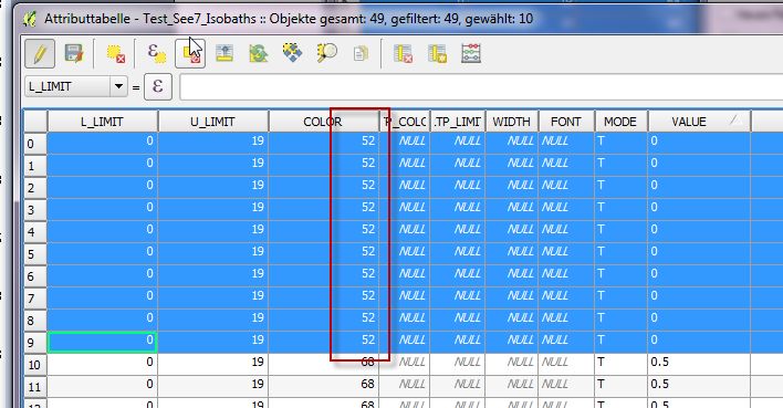
    Geändert werden solle einige Zeilen der Spalte COLOR
    und zwar alle mit dem VALUE-Wert "0".


Nun mit der linken Maustaste die Zeilennummern anmarkern soweit es gewünscht ist
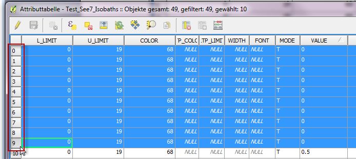

Feldrechner öffnen


Eintragungen vornehmen (die in der Abbildung verwendeten Einstellungen sind nur ein Beispiel und sollen das Prinzip darlegen) >>> OK


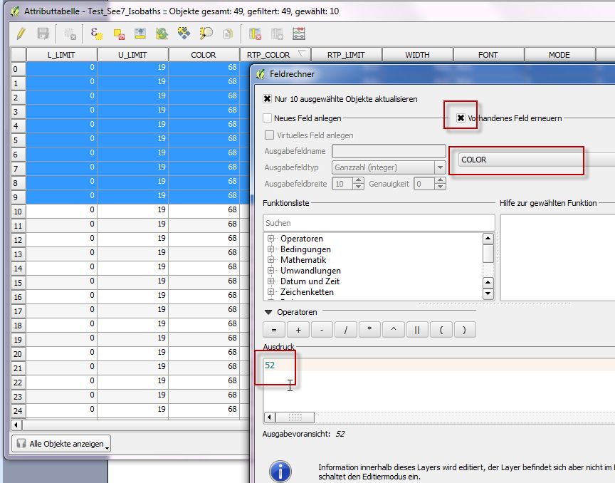
Im Ergebnis sind alle ausgewählten Zeileneinträge in der betreffenden Spalte mit einem Schlag verändert (Sichern/Speichern nicht vergessen).

TACKLE FEVER Forum

Offline arnesr

  • Jungbrut im Schwarm
  • *
  • Beiträge: 24
  • My/Mein Echo Equipment: Hook 4 5 7 9 , Elite 4 HDI + Chirp, Elite TI 5, Elite Ti2 9 + 12
I have found this forum post to be one of the most helpful in understanding how to work with attributes in QGIS for IMC usage.  In my opinion it is a shame that it is buried in an old Reefmaster thread as it directly relates to IMC.  Perhaps it would be appropriate to start a thread under the IMC documentation pointing here, as I think it would be helpful for others to see.

I have a related question to POIs.  I have a few shape files in my map that I use the INFO_BOX attribute to link to more information about the point.  On my gen 1 hook unit, when I hover the cursor over the icon I can see the detail contained in the INFO_BOX without actually pressing a button to select it.  When I load this map in newer units (TI, TI2, Hook2, Eagle) and when I hover over the point I see the information contained in the MIN_CAT attribute.  If I select the point I am able to drill down to the detailed INFO_BOX information, but it takes a few more button/screen presses.  I am guessing this has has to do with the differences between the Indigo-Violet operating system and the NOS operating system. 

I much prefer the way the Gen1 Hook handles this and was wondering if there was a way do accomplish this on a NOS system.  I did try to copy the information contained in the INFO_BOX to the MIN_CAT attribute.  This works on a limited basis it seems.  There seems to be a limit to the number of unique MIN_CAT attributes you can have in your map, as when I loaded several thousand POIS with unique MIN_CAT values the resulting map would not load and caused my unit to reboot continuously. I believe I exceeded what the unit can handle.  Are there any work arounds to this? 

The POIs that I am using relate to campsites that each have a unique number and rating that I have stored in the INFO_BOX.  For now I have sorted the campsites by rating (1-5) and have copied the rating into the MIN_CAT attribute.  This way I can see the rating when I put the crosshairs over the POI,  but I do not know then number until I select the POI detail.  It works, but is not ideal.

Offline fjordfischer

  • Moby Dick
  • *******
  • Beiträge: 2399
  • My/Mein Echo Equipment: HDS-7 Carbon, HDS-7 G3, HDS-7 G2, SS3D, echoMAP-71sv
If I've understood your request correctly, you may have made a mistake. Labels for the AT5 points are controlled via the "VALUE" text field. If, for example, you specify "Place xyz, rating 3" or only "3" as fix rating, then that is exactly what will be displayed as the point label. The (additional) informations in the text field INFO_BOX are limitet to 254 signs. With touchscreen units (i only use HDS) i need exactly 2 touches for find the this text, one to the point and the second to the following point label (as deposit MIN_CAT label). If you prefer to use unlabeled points, you can modify the color of the icons, for example 1 star = red to 5 stars = green (like a traffic light)

MIN_CAT is more intended for the defined display and hiding of elements in groups. The number of MIN_CAT and MAJ_CAT elements should really be kept as low as possibl, max a few of dozen, otherwise the system will be slowed down. Possible is also to use a similar chart with modified themes from the same place, which can be loaded by different chart name in the chart category, eg one with the place name and one other with the ranking number (over the field VALUE).

But while we're at it: Have you already tested the option of inserting pictures of the campsites via the information ("INFO_BOX")?

Offline arnesr

  • Jungbrut im Schwarm
  • *
  • Beiträge: 24
  • My/Mein Echo Equipment: Hook 4 5 7 9 , Elite 4 HDI + Chirp, Elite TI 5, Elite Ti2 9 + 12
fjordfischer thank you for the prompt reply. I value your thoughts and ideas as your IMC knowledge is vast and your responses are super helpful.

I have kept my campsites as unlabeled points to keep the map clean and uncluttered.  Currently I use three different colored icons for different types of campsites (Open, Closed, & Unverified) and all three are just a small dot, again to reduce clutter.   It doesn't sound like there is an option to change the behavior on an NOS system so that the hover over (cartoon bubble label) displays something other than the MIN_CAT value.  It is but a minor inconvenience, as you say the detailed info can be had with a couple more clicks. 

The map I am preparing is for a canoe fishing application with an off grid setup.  For this reason, a unit with a small screen is preferred to keep battery usage to a minimum.  I have a 5" TI unit, which works well for testing, but is still a bit more power hungry than I would like.  The unit I currently use in the canoe is a Gen1 Hook unit with a 4" screen. The unit is a bit slow at times, but I have become accustomed to it's quirks. (Let it boot fully like an older computer before you try to use it.)  I also have a Hook2 5" unit, but I have been reluctant to use it based on the push in connectors, inferior SD slot and the fact that Raster maps are not enabled. I am considering one of the new 5" Eagle units as the connectors have been improved with twist locks and I would also gain Genesis live mapping, but still no Raster support.  I tested one of these units at a local retailer and I was able to display my custom map and the interface seemed nearly identical to my hook2 unit.  I wish the HDS models were available in a smaller screen size for this application as they seem to have more options.

Thanks for confirming my suspicion that the excessive MIN_CAT entries were likely causing system issues.  I did not see this specified in the documentation, but it makes sense.

I have played around a bit with the attaching a photo to a point, but have not implemented it in my map.  My 1st Gen Hook unit does not support it, but it does work on my TI, TI2 and even Hook2 unit. It is a cool feature for sure.       

Offline fjordfischer

  • Moby Dick
  • *******
  • Beiträge: 2399
  • My/Mein Echo Equipment: HDS-7 Carbon, HDS-7 G3, HDS-7 G2, SS3D, echoMAP-71sv
What's wrong with the name (also shortened) as "Value" in very small font and a rating in a few categories as "MIN_CAT"?

As you describe it, only an Elite Ti Gen1 would do what you want and would have a 5" version (to be on the safe side, ask the dealer for grid capability in 5''). I was able to test the Ti Gen1, Gen2, FS in 7'' on rental boats myself. OK, only a bit slower as the HDS, but only one cumbersome SD-slot.

These units can still be bought in small quantities. Elite devices can do almost everything that the comparable HDS can do, Elite Ti Gen1 is only limited in the very new functions (e.g. ActiveTarget). The Eagle is also available as a 4" and 5" version. But I don't know anything about the grid capability and other features that the advertising discreetly hides.

Another note about MIN_CAT. For unknown reasons, the device sometimes does not adopt the map categories of a new AT5 map (just look under map categories) when you load it onto the SD card. Sometimes only a soft reset helps.

Offline arnesr

  • Jungbrut im Schwarm
  • *
  • Beiträge: 24
  • My/Mein Echo Equipment: Hook 4 5 7 9 , Elite 4 HDI + Chirp, Elite TI 5, Elite Ti2 9 + 12
You are correct, there is nothing wrong with adding a small font label with the campsite number.  I do that with the printed version of the map I take as a backup, prepared with QGIS.  I am just stubborn I guess seeing how my Gen1 Hook handles things differently and I prefer less clutter.  If I were to add the campsite label, I would limit viewing to certain zoom levels so the text would disappear zoomed in and not be a distraction while fishing. 

I wish the new Eagle 4" had charting capability, but it does not.  I find that size to be ideal for low power applications in paddle sport fishing.  It would compete well with the Garmin Striker4CV if it did have GPS.  Then again, Garmin locks things down, so you cannot do anything remotely close in regards to custom mapping, only live contours.  Long live IMC!

I will probably upgrade to the Eagle 5 at some point before next spring.  Hopefully there will be a sale coming up.:)

To be honest, I have not messed with map categories, I am not even sure if my units support it, probably, but I have not looked.